
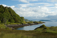
The small island of Barra forms part of the Outer Hebrides, a long chain of islands off the west coast of Scotland, stretching through the North Atlantic Ocean for a hundred miles. It takes over five hours to make the 70 nautical mile ferry crossing from the mainland to the island.
On Saturday 16th November 2013, a unique cultural map of the sea was launched at the Heritage Centre on Barra.

Sgeulachdan na Mara/Sea Stories, an online cultural
mapping project for Barra, has engaged with local people over the past year and
a half to develop an online cultural map featuring sound, image, story and
naming, that reveals the rich local
knowledge, language and culture based on their relationships with the sea
around Barra and Vatersay.
The project team of artist Stephen Hurrel and social ecologist Ruth Brennan have been working in partnership with VoluntaryAction Barra & Vatersay and Castlebay Community School in the recording and editing of audio-visual material for the online cultural map. As the older people of Barra are the main focus for gathering local names, stories, etc. this has created an interesting cross-generational oral history project.
A detailed view of the map below shows some of the icons used on the map (in this case, navigational buoys, mussel & pearl, red dots). Each icon can contain names
and active media (such as video, audio, photos, text, animations).
The marker buoy icons (below) indicate 'fishing marks'. Once the buoy is clicked
blue lines are drawn. These lines connect to features on land that local
fishermenuse to triangulate their position at sea, and to find
their 'fishing marks'.

The story of the Rusty Lobsters (which you can find on the map by clicking on the shipwreck called the 'Cullen') is an animated text and audio piece based on an anecdote from a local fisherman.

If you click a navigation buoy called Bo a' Chleirich (the Reef of the Priest) on the east coast of the map, you will find the story of how that reef got its name. The story, called the Altair Mor, is narrated by local historian Calum MacNeil and is illustrated in an adventure-comic-book-style.

The Sea Stories online cultural map was officially
handed over at the launch event on Saturday 16th November and is now a
permanent feature within the Barra community. It will continue to be added to
as further 'sea stories' are gathered by Castlebay School’s media students and
the wider community throughout the years. It will also be accessible to the
public at local cultural events and to the wider world via the Internet.
Sgeulachdan na Mara/Sea Stories grew out of
collaborative research undertaken by social ecologists Ruth Brennan and Iain
MacKinnon and audio-visual material generated by artist Stephen Hurrel, for the
publication Dùthchas na Mara/Belonging to theSea (Authors: MacKinnon and Brennan. Photographs: Hurrel).
The idea of a dynamic map - to reflect
intergenerational knowledge, fishermen’s ways of knowing the sea and the
intangible cultural heritage* of the marine environment - had been
discussed by Brennan and MacKinnon, and Hurrel proposed the idea of an
interactive digital map. This was subsequently developed by Hurrel and Brennan
as a way of bringing to life, and making visible, what is often invisible to
most people. Hurrel and Brennan decided to
collaborate on a Barra-related project following their participation in Cape Farewell’s Scottish Islands Expedition 2011.
The best way to experience this unique interactive cultural map of the sea is to explore it for yourself. Enjoy!
*The UNESCO Convention for the
Safeguarding of Intangible Cultural Heritage 2003 provides international
protection for the intangible aspects of cultural diversity.


Wonderful inventive research work, accessible to all.
ReplyDelete